Faro de Punta Jandia - Parque Natural de Jandia

Sonnenuntergänge am Faro de Punta Jandia

Ganz im Südwesten befindet sich einer der schönsten Leuchttürme von Fuerteventura. Der Faro de Punta Jandia. Man fährt einfach durch Morro Jable durch. Auf der selben Piste welche auch nach Cofete führt. Faro de Punta Jandia - Parque Natural de JandiaDas Wort Straße benutze ich mal absichtlich nicht, denn kurz hinter Morro Jable hört sie auf eine wirkliche Straße zu sein. Ab da wird sie eher zur Buckelpiste. Sie führt etwa 20 Kilometer durch das Naturschutzgebiet Parque Natural de Jandia. Etwa auf der Hälfte der Piste kommt eine Abzweigung welche in die Berge nach Cofete führt. Bevor man zum Faro de Punta Jandia fährt, sollte man kurz nochmal einen Blick in den Mietwagen Vertrag werfen. Es handelt sich bei der Piste zwar um eine offizielle Straße.

Jedoch die meisten Verträge, bzw deren angehängte Versicherungen gelten nur für asphaltierte Straßen und schließen diese Art der Pisten aus. Und die Gefahr auf einen Glas oder Lackschaden ist recht groß. Interessanter weise sind die letzten 3-4 Kilometer neu gemacht und Top asphaltiert. Der Leuchtturm wurde erst mit EU Hilfe renoviert und wie es aus sieht sind auch noch ein paar Kilometer Asphalt mit drinn gewesen.

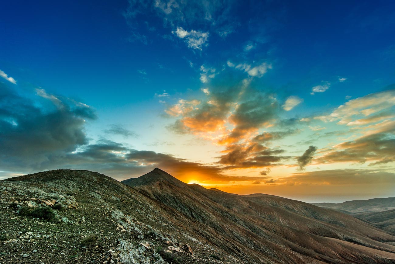
Einmal dort angekommen hat man natürlich eine tolle Aussicht. Es fahren vielen Fähren vorbei und bei gutem Wetter kann man bis Gran Canaria sehen. Allerdings kann es dort auch sehr windig sein. The Punta Jandia LighthouseVor allem gegen Abend. Also auf jeden Fall eine Jacke mit einpacken. Und natürlich die Kamera nicht vergessen. Die Sonnenuntergänge dort sind einfach traumhaft. Und mit etwas Glück man ist dort fast alleine. Wir waren es damals jedenfalls. Die meisten anderen saßen wohl schon im Hotel beim Abendessen.

In the southwest of Fuerteventura is possibly the most beautyfull lighthouse of the whole island. The Punta Jandia Lighthouse. Behind Morro Jable, after about 20 kilometers of gravel roads you are there. At the end of Fuerteventura. With a little bit of luck you can see all the ferrys passing by and Gran Canaria. But the best time to be there is sunset. So don’t miss it, and carry a jacket with you, it’s very windy there.

Wandern im La Orotava Tal // Hiking at the Orotava Vally

Die Landschaft zwischen Pico de Teide und dem Orotava Tal

Entlang eines kleinen Wanderweges zwischen dem Orotava Tal und der Caldera Las Canadas. Gleich am Anfang der TF-24 Richtung Santa Cruz gibt es auf der linken Seite einen kleinen Parkplatz. Wanderweg La Orotava Tal // Hikingtrail Orotava ValleyDort beginnt der Wanderweg um einen Hügel vulkanischen Ursprungs. Er dürfte so ca 3-4km lang sein. Das ist gut in einer Stunde zu schaffen. Man ist kurz oberhalb der Baumgrenze, hat also einen freien blick auf den Pico de Teide. Außerdem sieht man die Natur in dem davor liegenden Orotava Tal sehr schön. Mit etwas Glück kann man sogar die Wolken beobachten. Wie sie vom Meer aus über Puerto de la Cruz kommend, hoch in die Caldera ziehen. Es handelt sich hierbei übrigens um einen Rundweg, man kommt also am Ende wieder auf dem Parkplatz raus. Dort gibt es auch ein paar Bänke für eine Essenspause 🙂

Den Namen des Parkplatzes, oder eine Bezeichnung für den Wanderweg konnte ich leider nicht mehr raus finden. Aber der Parkplatz gehört zu einer Sehenswürdigkeit. Dort hat man ein paar Überreste oder eine Kultstätte der Guanchen ausgegraben. Auf google maps sieht man das recht gut.

Small hiking trail with a nice Orotava Valley view

Starting at a parking place on the TF-24, only a kilometer after the El Portillio service area. The place is marked an old Guanche monoment. Hikingtrail la Orotava // Orotava Tal WanderwegBut its also the start for a short hikingtail arount a local hill. The trail is only about 3-4 kilometers long. But you have a realy nice view over the whole area there. Also a nice view for the Pico del Teide with the pineforrest in the foreground. And with a little luck there are also some moving clouds, comming from Puerto de la Cruz. I enjojed this trial very much. Because it gives me the possibility to take several pictures around the vally and the caldera.

Die Rapsblühte 2016 // The rape blossom season in 2016

Die Rapsblühte

Dieses Jahr hat die Rapsblühte irgendwie später an gefangen. Jedenfalls in der Wetterau in Mittelhessen. In den letzten jahren ging es immer so grob nach Ostern los. Wenn Ostern spät war, hatte ich meine Rapsfeldshootings sogar an Ostern. Aber dieses Jahr hat es bis angang Mai gedauert, bis die Rapsfelder so richtig schön gelb waren. Das sagt schon viel aus, über das nicht vorhandene Frühjahr.

Die Rapsblühte 2016 // The rape blossom season in 2016 Natürlich war ich nicht nur wegen dem Raps als solchem dort unterwegs. Zwischen Hintertaunus und Wetterau auf der Höhe von Bad Nauheim, gleich neben der A5. Primär hab ich dort, wie eigentlich jedes Jahr ein paar verrückte Bilder mit unpassenden Kostümen gemacht. Dafür bin ich bekannt 🙂 Für meinen Rapsfeld Fetisch. Die Landschaftsfotos sind nur nebenbei entstanden, wärend sich die Models um gezogen haben. So ein Rapsfeld bietet einem ja sehr viele Möglichkeiten. Auf jeden fall ist nach dem Shooting immer das große Säubern der Ausrüstung angesagt. Die Pollen setzen sich einfach über all fest.

The canola flower season in 2016

I don`t realy know if canola flower or rape seed is the correct word for this flower. My dictionaries give me both possibilities. And I don`t know it the farmer use it to make oil or to feed the animals. Die Rapsblühte 2016 // The rape blossom season in 2016Here in Germany we have one word for both. But who cares 🙂 The rape blossom season (Rapsblühte) starts late this spring. Normally I am out in the fields the week after easter. But this year it takes till the beginning of may till the blossoms turns into realy yellow. But than, the area between Bad Nauheim and Obermörlen, in the middle of the state Hessen is full of them. It starts right beside the highways and goes toll the villages. The whole area is yellow than 🙂

La Gomera hiking imressions

La Gomera hiking impressions

My La Gomera hiking impressions. Taken at a hiking trip to La Gomera last year. The clouds move throu the mountains. The trees are milking the water out of the clouds. That makes the wood very wet and foggy. Its a dark and silent mood out there. Like beeing in a fairytale. We did a hiking trip over the island. From the sunny coast deep into the mountains. We also met a lot of backpackers there. There are a few camping possibilities. But you can also do day trips there. With the ferry Tenerife or something like that.

Historical Satellite Dishes

Historical Satellite Dishes

There are a lot of Molinos and Molinas around Fuerteventura. They have a different architecuture as the windmills in north europa. There wings have the size of satellite dishes for broadcastind something. So for me they look like a kind of historical satellite dishes. Like they have broadcasted something centurys ago with thouse historical satellite dishes. A signal to the great ships who conquered the new world. But the wings size makes sense because Fuerteventura is full of wind. You have more a problem with to much wind as with to low. A lot of Thouse Molinos and Molinas are very small. I guess many farmers have had there own.

Pájara

Pájara Mountain Sundowns

Traveling the FV-605 road from La Pared to Pájara. On the half way, a view kilometers after crossing the FV-618 to Cardón you will get higher into  the mountains. After a view minutes you are at a high level of about 500 meters. And there is a bouth sides parking place with a footway up to the top. The Point is called Sicasumbre viewing point. You have a great view to both sides of the mountain there, and into a yellow red shining valley till Pájara. No plants or trees in your way. Fast moving clouds in the sky. So thats the place where I did my sundown pictures. But beware, its an very high wind blasting area. And with that wind it could be 10 to 15 degree colder.

Wenn man die FV-605 von La Pared kommend Richtung Pájara fährt, kommt man ein paar Kilometer nachdem sie die FV-618 Richtung Cardon gekreuzt hat zu einem Parkplatzt. Etwa auf 500 Meter Höhe. Dort gibt es einen Fußweg hoch auf die Bergspitze. Ausgeschildert sind Aussichtspunkte in Spanien immer als Mirador. Sehr wichtig, da es in den Bergen von Fuerteventura kaum Möglichkeiten gibt neben der Straße zu halten. Von dort hat man eine super Aussicht zu alles Seiten. Über das Tal das Richtung Norden nach Pájara führt. Oder Richtung Südspitze der Insel wo die Sonne unter geht. Das ist die Stelle von der aus ich diese Sonnenuntergansbilder gemacht habe.

The masca trail, down to Los Gigantes

The Masca trail, down to Los Gigantes

The Masca trail is one of the popular hiking trails on Tenerife. The trail starts in a small village called Masca  on top of the mountains, and goes straigt down to the sea. You follow a creek down to an old canyon straigt away to the coast. It depends on the season, the creek could be empty or full with water till your knees. The village is on a high level at about 800 meters and on the end of the trail you will see the cliffs of Los Gigantes. There you hafe the chouce to walk back to Masca or to take a water taxi to the Los Gigantes village. You need good hiking boots ant it will takes you about 3,5 hours. And becarefull, there are some bad accidents every year.

San Sebastian

San Sebastian de La Gomera

Some ferry impressions of San Sebastian de la Gomera. Thats what you see when you took the ferry from Tenerife to la Gomera. The harbour and the cityline of San Sebastian de la Gomera. The main village on la Gomera. Because La Gomera has no airport, you have to take the ferry or a boat to get there. And the island welcomes you with his nice little main village. It was out strartingpoint for a hikingtrip to La Gomeras well known rainforest out there in the hills. The so called fairytale forest. There are a lot of backpackers on La Gomera, its a great nature.

desert vineyard

A desert vineyard

A destert vineyard. Thats how they growe grapes and make wine on Lanzarote. In an vulcano based desert area near the city of Yaiza. The stone walls are to protect the grapes from the wind. Ity a very try area, mostly no rain. Therefore they dig thouses holes wherethey put the grapes in. They are like a funnel. The stones are vulcano based. The stones suck the humidity right out of the morning dew and the funnel brings it to the plant. An impressive desert vineyard. It must be a very arduous kind of work, planting in such an try area. The desert vineyard

Dunas de Maspalomas

The great Dunas de Maspalomas

The great Dunas de Maspalomas are sand dunes in the south of Gran Canaria. Its a well known place for tourists. The gread task the Dunas de maspalomas is not the sand or the winds. Its to get your picture free of people, specialy free of nude people. The dunas are popular by the nudity communinty and very popular by the gay community. And both are don t like people with huge cameras. They always expect a peeping tom or pervert behind. And not a nature photographer. I was on there with my D800 the Nikon 14-24 and my Nikon 70-200mm. So I attract much attension.

Puerto de Mogan

Puerto de Mogan

Puerto de Mogan – The small village in the south of Gran Canaria. Easy to reach with the local bus system. You dont need a car to go there. There are less parking possibilities in Puerto de Mogan and its a small village so you can do everything there by foot. I went there wit the local bus direct from Maspalomas. Its about halt an hour. Just for a day trip. Its a nice little village for relaxing, drinking some coffe or walking around. They have a lot of flowers there, white painted houses with blue doors. The bay beach is wind and waves protected, so take your swimming things with you.

La Graciosa

La Graciosa

Sadly we have got windy weather and a cloudy sky on our day trip to the smal canary island La Graciosa. I just can imagine how beautyfull La Graciosa would be with bright sunlight and a blue sky. But for all that I enjoeyed my trip to La Graciosa very much. It is the smallest inhabiteted island of the canaries. It has only 29,05 square kilometers and its in the north of Lanzarote. We took the ferry from Orzola to Caleta del Sebo, the small main village. After a lunch break we went out for a short hiking trip over the island and took the last ferry back to Lanzarote. And the bus back to our horror hotel in Costa Brava.

Colorfull snail shell on the crater bottom of Lanzarotes Vulcano Montana Roja

A snail shell at the crater bottom.

First I found a snail shell. On a place I dont expect to found anything. I was on my way to the top of Lanzarote`s Montana Roja. A 200 meter high and dead old vulcano in the south of Lanzarote, near Playa Blanca  Than I found a nother colorfull snail shell. And than a lot of snail shells. Seems there is more life in old vulcano craters than I expected. Specialy on islands full of sand and stones. The bottom was full of small plants, snail shell`s, some rabbits and lizzards. More natural vegetation  as I saw in the rest of the island.

La Gomera

Some coastline impressoins of La Gomera

When you come down the road from the La Gomera rainforest mountains, the first things you see are some houses and the atlantic see. It goes staight ahead down to the coast. In this case the north east coast of La Gomera. With Tenerife in the background. Its a complete change of colors. The dark green and spooky forest on the top, with all the fog and clouds passing throu and the sunny coast with beaches and the blue sea. White painted houses with red roofs, banana plantations and very curvy roads. It was a stop back on my way to the ferry in San Sebastian. I have been on La Gomera for a hiking trip. And thouse pictures are beside impressions from this trip. It was not a phototrip 🙂

The shifting sand dunes of Maspalomas

Sand and Sky – The beautyfull Dunes of Maspalomas

The beautyfull dunes of Maspalomas. Impressions from my last journy to Gran Canaria. The dunes of Maspalomas are a 6×2 square meters areal in the south east of Gran Canaria. The best time to stay there is between the end of April and die beginning of june. Before April its very windy there, so you have some problems with sand, your towel or umbrella and after june the sand is (for me) to hot. The dunes are not so empty as they looks on my pictures. On some days they are full of members of the gay community or of full nudity people. Out there is a big full nutity area. But who cares, its a nice place for taking pictures, The Sand is very finely granulated and the wind makes nice patterns in the dunes. On one side there is a small lake, the left of a former laguna who was taken step by step by the sand. Its a breeding area for a lot of birds and a wildlife sanctuary. Net time I will come with a ND Filter doing some long time exposure.


Puerto de Mogan

The beach side of Puerto de Mogan

Puerto de Mogan, the small beautyfull fishing village in the south west of Gran Canaria. With the white painted small houses, alle Palms and flowers around, Puerto de Mogan realy looks like it was just build for travel catalogue pictures. OK not all of Puerto de Mogan looks realy nice. There are also some „Cement Castles“ as we call in germany the quick buils tourism hotels of the 80th. But they are a little bit away from the coast side of the village. Fot the most people its important how the beach and the water area looks like. And I can say. beautyfull. The beach and the harbor are man made, not natural as in Maspalomas. Because of that the beach of Puerto de Mogan is sheltered from the wind and the water is a little bit warmer. Its perfect for a nice day trip. To have a little swim, a good meal, and to walk around. We have been there with the public bus system. It works very good on Gran Cararia and it is cheap.  But please, take a look at the pictures and you wiill see what I mean.