Magische Wanderwege im Anaga-Gebirge

Magische Wanderwege im Anaga-Gebirge

Magische Wanderwege im Anaga-Gebirge


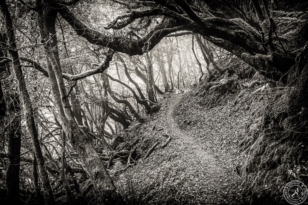
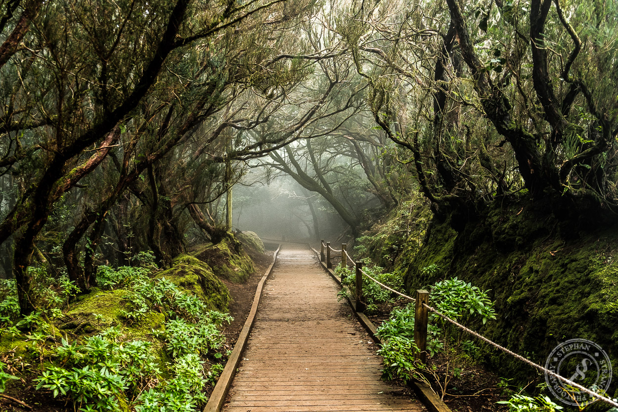
Das Anaga-Gebirge im Osten von Teneriffa ist schon ein verwunschener Ort. Man könnte meinen dieser Wald wurde von Tim Burton erschaffen. Jedenfalls fühlt man sich sofort wie in einem düsteren Märchenfilm. Jeden Moment kann der kopflose Reiter aus Sleepy Hollow um die Ecke geritten kommen. Dichter Lorbeer Urwald, knorrige, verwachsene Bäume und zwischen drin tolle Wanderwege. Schlechtes Wetter gibt es dort eigentlich nicht, es ist immer neblig und feucht, das Wasser tropft von den Bäumen und verfängt sich in Flechten und Moosen. Der Wind peitscht die Wolken vom Atlantik her durch das Anaga-Gebirge, die Wassertropfen bleiben an den Pflanzen und Blättern kleben. Der Wechsel zwischen Sonne und Nebel dauert nur Sekunden. Eben noch das Objektiv gewechselt, schon sieht man nichts mehr.

Ein Teil der Wanderwege ist mit Holzplanken befestigt, der Großteil geht aber über feuchten, roten Boden. Je nach Wetterlage kann dort gerne auch mal etwas Wasser ab fließen.

Vilaflor de Chasna auf Teneriffa

Vilaflor de Chasna auf Teneriffa

Vilaflor de Chasna ist mit seinen 1400 Metern der höchst gelegene Ort auf Teneriffa. Umgeben von Mandelplantagen, Pinienwäldern und ausgiebigen Wanderwegen lädt er zum verweilen ein. Im Ort selbst gibt es eine alte Wassermühle zu bestaunen, Vilaflor de Chasna auf Teneriffa mit der Kirche San Pedromit welcher früher das Maismehl für den Gofio gemahlen wurde. Die Mühle ist restauriert und begehbar. Sehr schön an zu schauen ist auch die Kirche San Pedro aus dem 17 Jahrhundert. Erbaut im Kanarischen Stiel, das heißt schön weiß gestrichen mit einem ansehnlichen Dorfplatz davor, inklusive Olivenbaum. Was will man mehr. Der einzige Heilige, der von den kanarischen Inseln kommt, San Pedro de San José Betancur ist übrigens in Vilaflor gebohren. Papst Johannis Paul II hat ihn 2002 für sein wirken in Guatemala heilig gesprochen. Und das ist vor Ort nicht zu übersehen. Man brauch nicht mal ein Auto um nach Vilaflor zu kommen. Die alte Wassermühle in Vilaflor de Chasna auf Teneriffa.Das öffentliche Bus System ist gut aus gebaut. Vom Süden aus gibt es tolle Verbindungen für einen Tagestrip mit ausgedehnter Wanderung.

Vilaflor is with 1400 meter the highest village at Tenerife. Suroundet by Pine Forest and a lot of hiking trails it’s an ideal starting point for daytrips into the mountains. You even don’t need a car, there is a great public bus system at tenerife.

Wandern im La Orotava Tal // Hiking at the Orotava Vally

Die Landschaft zwischen Pico de Teide und dem Orotava Tal

Entlang eines kleinen Wanderweges zwischen dem Orotava Tal und der Caldera Las Canadas. Gleich am Anfang der TF-24 Richtung Santa Cruz gibt es auf der linken Seite einen kleinen Parkplatz. Wanderweg La Orotava Tal // Hikingtrail Orotava ValleyDort beginnt der Wanderweg um einen Hügel vulkanischen Ursprungs. Er dürfte so ca 3-4km lang sein. Das ist gut in einer Stunde zu schaffen. Man ist kurz oberhalb der Baumgrenze, hat also einen freien blick auf den Pico de Teide. Außerdem sieht man die Natur in dem davor liegenden Orotava Tal sehr schön. Mit etwas Glück kann man sogar die Wolken beobachten. Wie sie vom Meer aus über Puerto de la Cruz kommend, hoch in die Caldera ziehen. Es handelt sich hierbei übrigens um einen Rundweg, man kommt also am Ende wieder auf dem Parkplatz raus. Dort gibt es auch ein paar Bänke für eine Essenspause 🙂

Den Namen des Parkplatzes, oder eine Bezeichnung für den Wanderweg konnte ich leider nicht mehr raus finden. Aber der Parkplatz gehört zu einer Sehenswürdigkeit. Dort hat man ein paar Überreste oder eine Kultstätte der Guanchen ausgegraben. Auf google maps sieht man das recht gut.

Small hiking trail with a nice Orotava Valley view

Starting at a parking place on the TF-24, only a kilometer after the El Portillio service area. The place is marked an old Guanche monoment. Hikingtrail la Orotava // Orotava Tal WanderwegBut its also the start for a short hikingtail arount a local hill. The trail is only about 3-4 kilometers long. But you have a realy nice view over the whole area there. Also a nice view for the Pico del Teide with the pineforrest in the foreground. And with a little luck there are also some moving clouds, comming from Puerto de la Cruz. I enjojed this trial very much. Because it gives me the possibility to take several pictures around the vally and the caldera.

La Gomera hiking imressions

La Gomera hiking impressions

My La Gomera hiking impressions. Taken at a hiking trip to La Gomera last year. The clouds move throu the mountains. The trees are milking the water out of the clouds. That makes the wood very wet and foggy. Its a dark and silent mood out there. Like beeing in a fairytale. We did a hiking trip over the island. From the sunny coast deep into the mountains. We also met a lot of backpackers there. There are a few camping possibilities. But you can also do day trips there. With the ferry Tenerife or something like that.

The masca trail, down to Los Gigantes

The Masca trail, down to Los Gigantes

The Masca trail is one of the popular hiking trails on Tenerife. The trail starts in a small village called Masca  on top of the mountains, and goes straigt down to the sea. You follow a creek down to an old canyon straigt away to the coast. It depends on the season, the creek could be empty or full with water till your knees. The village is on a high level at about 800 meters and on the end of the trail you will see the cliffs of Los Gigantes. There you hafe the chouce to walk back to Masca or to take a water taxi to the Los Gigantes village. You need good hiking boots ant it will takes you about 3,5 hours. And becarefull, there are some bad accidents every year.

San Sebastian

San Sebastian de La Gomera

Some ferry impressions of San Sebastian de la Gomera. Thats what you see when you took the ferry from Tenerife to la Gomera. The harbour and the cityline of San Sebastian de la Gomera. The main village on la Gomera. Because La Gomera has no airport, you have to take the ferry or a boat to get there. And the island welcomes you with his nice little main village. It was out strartingpoint for a hikingtrip to La Gomeras well known rainforest out there in the hills. The so called fairytale forest. There are a lot of backpackers on La Gomera, its a great nature.

La Gomera

Some coastline impressoins of La Gomera

When you come down the road from the La Gomera rainforest mountains, the first things you see are some houses and the atlantic see. It goes staight ahead down to the coast. In this case the north east coast of La Gomera. With Tenerife in the background. Its a complete change of colors. The dark green and spooky forest on the top, with all the fog and clouds passing throu and the sunny coast with beaches and the blue sea. White painted houses with red roofs, banana plantations and very curvy roads. It was a stop back on my way to the ferry in San Sebastian. I have been on La Gomera for a hiking trip. And thouse pictures are beside impressions from this trip. It was not a phototrip 🙂

The Guajara mountain

Guajara Mountain a part of the caldera Las Canadas

Mostly the Guajara mountain stands in the shaddow of the Pico del Teide. thats sad, because the Guajara is allways a visit worth. There is no ropeway or road to the top, but you dont need to be an climbing expert to get on top. Good hiking boots and enough time are enough. On top you are on an high level of 2715 meters with a view over the south of Tenerife, Cran Canaria and La Gomera. On the North side you can look over the the Caldera Las Cañadas with one of the best viewes for the Pico del Teide. On the last picture you can see a Guardia Civil helicopter you . The start searching a missing hiker who startet one day before us to climb up to the top. Its not a very risky tour but at this time of the year there are some slippery frozen parts on the way. So its better to do a guided tour. In the 10 days we stay on this island, they don`t found the missing hiker.

Ein klein wenig steht der Guajara immer im Schatten seines kleinen Bruders Pico del Teide. Wobei ich muß sagen, als Berg hat er mir wesentlich mehr spaß gemacht. Auf der Wanderung hat man sehr wenig Leute getroffen, und oben waren auch keine Massen zu sehen im Gegensatz zum Teide, wo einem sehr viele mit Flip Flops besohlte Touristen per Seilbahn entgegen kommen. Von der Sicht her ist man auf 2715m Höhe weit über den Wolken und kann bei gutem Wetter den Flughafen, Costa Adeje und auf jedenfall Cran Canaria und La Gomera sehen. Es gibt einen leichteren und einen schwierigeren Weg hoch zum Guajara. Wir sind den schwierigeren hoch, und den leichteren wieder runter. Schon alleine damit noch etwas Zeit zum Fotografieren bleibt. Die hat man beim Aufstieg nicht wirklich.

The La Orotava Vale with Pico del Teide in the Background

La Orotava Weather View

At a high level of 1000 meters you have good view over the Orotava vale with his coniferous forest, the clouds coming from the atlantic ocean an the north east side of the vulcano Pico del Teide.

Auf 1000 Höhenmetern hat man eine gute Übersicht über das Gebiet von la Orotava welches sich von der Küste bei Puerto de la Cruz bis hin zum Pico del Teide erstreckt.


The Caldera Las Canadas

The Caldera Las Cañadas

The Caldera ( „A caldera is a cauldron-like volcanic feature usually formed by the collapse of land following a volcanic eruption. They are sometimes confused with volcanic craters. The word comes from Spanish caldera, and this from Latin caldaria, meaning „cooking pot. “ (wikipedia)) is called Las Cañadas ( Las Canadas). Its an over 17 Kilometers diameters elevated plain area in the Teide national park. A lots of movies are filmed there. Clash of Titans, Star Wars Ep III for example. I did this area pictures while climbing up th the Guajara Mountain. On the last picture you can see a Guardia Civil helicopter you . The start searching a missing hiker who startet one day before us to climb up to the top. Its not a very risky tour but at this time of the year there are some slippery frozen parts on the way. So its better to do a guided tour. In the 10 days we stay on this island, they don`t found the missing hiker.

Impressionen von einer Wanderung durch die Caldera las Canadas. Ein sehr schönes, ca 17km2 großes Gebiet das sich unterhalb des Vulkans Pico del Teide erstreckt. Natürlich darf bei so einer Wanderung auch meine Kamera nicht fehlen. Wobei es ab und an echt mühsam ist das ganze Geraffel mit zu schleppen. Vor allem wenn es Berg auf geht. Aber dafür entschädigt einen dann der Blick über Las Canadas. Vor allem wenn man an Orten vorbei kommt an denen schon Star Wars oder Kampf der Titanen gedreht wurde. Nicht ganz so schön waren die Begegnungen mit den Rettungstrups die einen seit dem Vortag auf selbiger Strecke vermissten Bergsteiger suchten. Ist schon ein komisches Gefühl wenn man an einem Abgrund steht und um einen Herum ein Rettungshubschrauber kreist. Leider wurde die Person nie gefunden. Dennoch werden wir Las Canadas bestimmt noch einen Besuch ab statten.

The fairytale forest of La Gomera

La Gomera Fairytale Forest in Black & White

Impressions taken on a hiking trip deep into the La Gomera rain forest, the so called fairytale forest. It looks very much there like into a Sleepy Hollow or Brother Grimms Fairitale movie. The nature there is dark green and very foggy, beause the atlantic couds move direct throu the forrest. Roots and lianas hanging around from the trees and everything is full with moss and lichen. To get more auf the hauting spirit I decided to take thous pictures in black and white.

Man kann echt meinen man wäre in einem Märchen der Brüder Grimm wenn man durch den Regenwald von La Gomera wandert. Über all hängen Flechten oder Lianen von den Bäumen herunter, es ist dunkel und sehr nebelig weil die Wolken direkt durch den Wald ziehen. Die Steine und Stämme sind komplett mit Moos bedeckt. Hat an manchen Stellen schon fast was von Sleepy Hollow. Ich finde ein Schwarz Weiß transportiert sich die Atmosphäre von dort nochmal wesentlich besser. Vom Wetter und dem Rest bekommt man im Wald nicht viel mit. Es ist immer leicht dunkel und nebelig. Also eine gute Aussicht oder so hat man dort nicht wirklich, obwohl man auf über 1000 Meter ist. Aber die braucht es ja auch nicht immer. Dafür gibt es andere Orte auf La Gomera


Pico del Teide

Best view for the Pico del Teide

If you want to have one of the best views for the Pico del teide, don`t go up to the Teide, climp up to the top of the 2718m high vulcano based Guajara Mountain. As you can see from there you have a very nice view over the Cañadas with the full Puco del Teide in the Background. I was there in the beginning of january, so as you can see, both Mountaus where covert partly with snow. Its an tropical area but at this highs the snow stays partly in the shadow areas. And it makes you a nice foreground for taking pictures 🙂 On the last picture you can see a Guardia Civil helicopter. The start searching a missing hiker who startet one day before us to climb up to the top. Its not a very risky tour but at this time of the year there are some slippery frozen parts on the way. So its better to do a guided tour. In the 10 days we stay on this island, they don`t found the missing hiker.

Um einen Berg zu fotografieren ist es selten schlau auf diesen zu steigen. Genau so ist das auch beim Pico del Teide, dem höchsten Berg Spaniens. Eine super Sicht auf den Pico del Teide hat man vom Guajara aus, einem 2715m hohen Berg im Süden der Caldera Las Canadas. Von dort aus hat man einen schönen Überblick über die Caldera und eine super Sicht auf den Pico del Teide. Das diese Gegend nicht ganz ungefährlich ist zeigte uns ein Rettungshubschrauber und Suchtrupps die auf der Suche nach einem vermissten Bergsteiger, einem bekannten Sportler der Insel waren. Leider hat man ihn nicht gefunden.


Great sky view from the Guajara Mountain

The great sky view

The great sky view from the top of the 2718m high Guajara Mountain over the Atlantic Ocean and the Canary islands. On one of the picures you can see Cran Canaria far away, on a nother the island of la Gomera. And you have also a great sky view over the Caldera Las Canadas. In my opinion the Guajara is a better place for a grat sky view on tenerife as the Pico del Teide. The Teide is higher but full of tourists with flipflops and shorts comming on top with the cable car. For this great sky view I backpacked my Kata photo bag with a ull frame and 4 lenses all the way up to the mountain by food. All for taking this grat sky view 🙂

Ich muß sagen mir gefällt die Aussicht vom Guajara aus wesentlich besser als vom Pico del Teide, obwohl dieser doch fast 1000 Meter höher ist. Auf dem Guajara hat man mehr Ruhe und es kommen einem nicht so viele Touristen in Flipflops und Hot Pants entgegen wie auf dem Teide. Vor allem sehr sinnvoll bei unter 10° 🙂 Aber da hoch gibt es ja auch keine Seilbahn, sondern man muß den ganzen Weg zu fuß bewältigen. Mehr über Stein als über Stock, und ab und zu recht harkelig, aber für ein gutes Bild oder eine gute Aussicht ist einem ja kein Weg zu weit. Außerdem hat man vom Guajara aus auch noch einen super Blick auf den Pico del Teide, und vor allem über die Caldera Las Canadas mit dem Pico del Teide als Hintergrund. Als Hobby Fotograf ist man ja das Leiden gewohnt, warscheinlich würde auch sonst niemand freiwillig sein ganzes Geraffel in einem Rucksack mit ganz bis oben auf die Spitze schleppen. Zusätzlich zum Wasser und dem Profiant. Aber man will es ja so 🙂

Teide – looks like the lonely mountain

The snow coverd Pico del Teide viewed from the Anaga mountains. On my last trip to Tenerife Island, I also take a hiking tour to the every green Anaga Mountains. Viewed from there, Pico del Teide, the third highest active vulcano of the world,  looks for me much like the lonely mountain in the Hobbit movies.