Colorfull snail shell on the crater bottom of Lanzarotes Vulcano Montana Roja

A snail shell at the crater bottom.

First I found a snail shell. On a place I dont expect to found anything. I was on my way to the top of Lanzarote`s Montana Roja. A 200 meter high and dead old vulcano in the south of Lanzarote, near Playa Blanca  Than I found a nother colorfull snail shell. And than a lot of snail shells. Seems there is more life in old vulcano craters than I expected. Specialy on islands full of sand and stones. The bottom was full of small plants, snail shell`s, some rabbits and lizzards. More natural vegetation  as I saw in the rest of the island.

The Guajara mountain

Guajara Mountain a part of the caldera Las Canadas

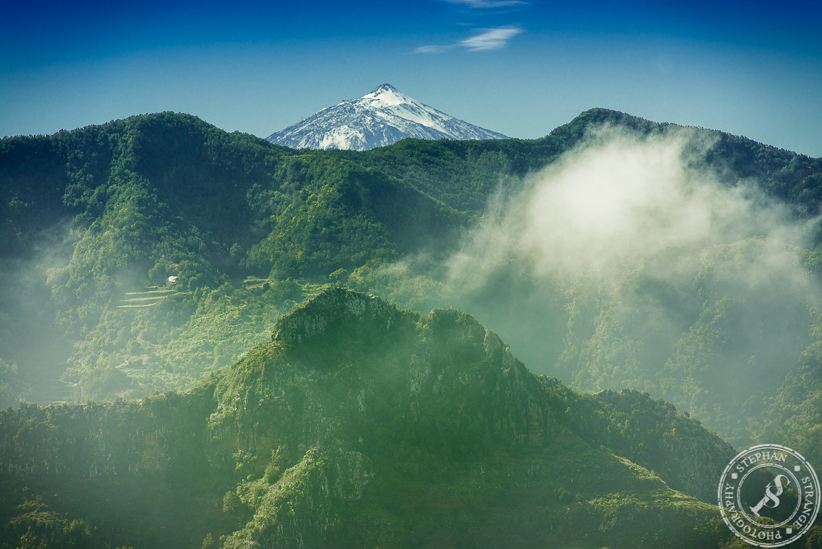
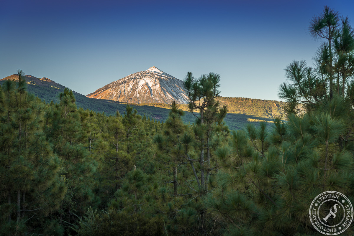
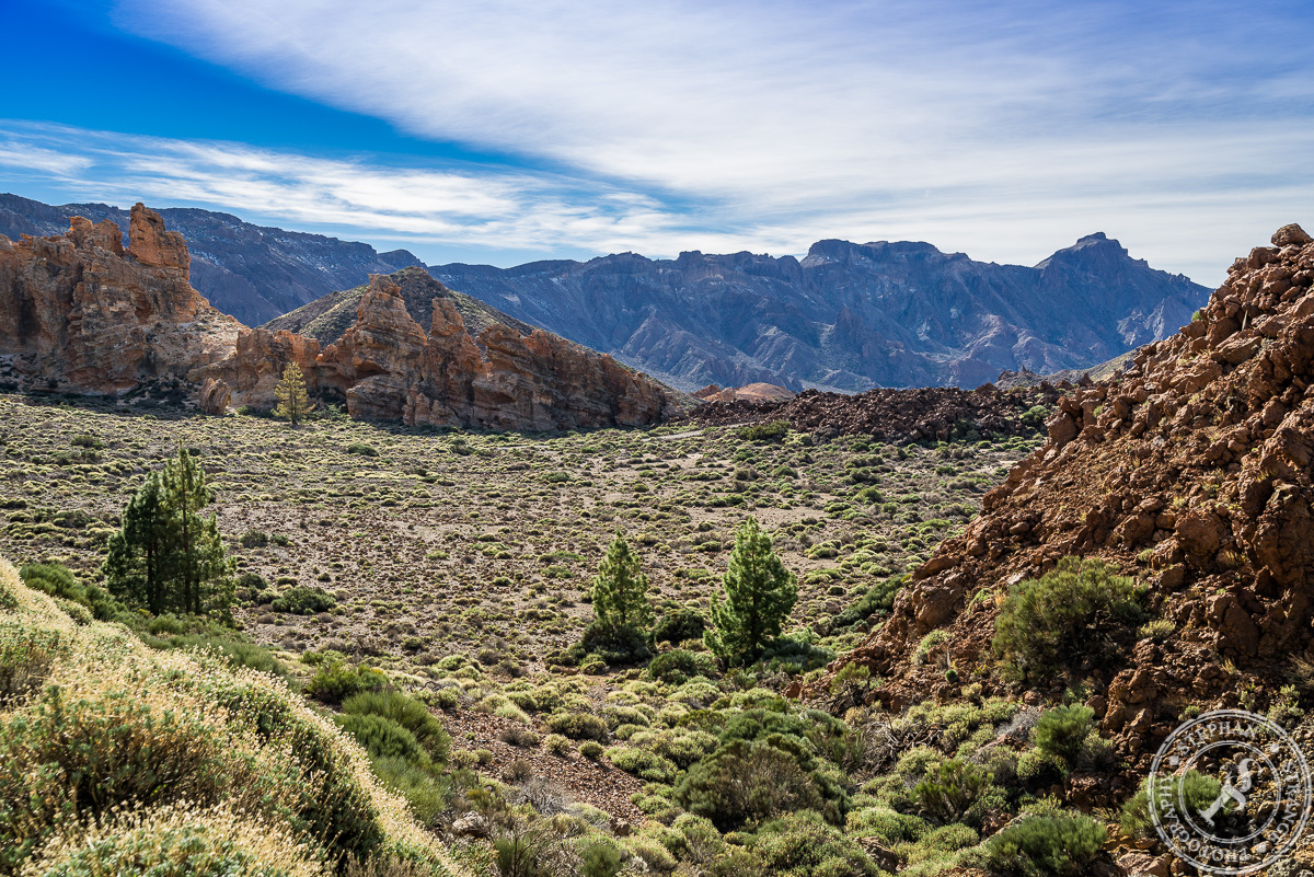
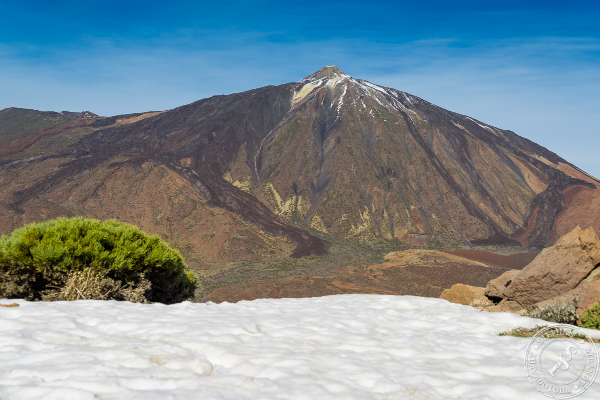
Mostly the Guajara mountain stands in the shaddow of the Pico del Teide. thats sad, because the Guajara is allways a visit worth. There is no ropeway or road to the top, but you dont need to be an climbing expert to get on top. Good hiking boots and enough time are enough. On top you are on an high level of 2715 meters with a view over the south of Tenerife, Cran Canaria and La Gomera. On the North side you can look over the the Caldera Las Cañadas with one of the best viewes for the Pico del Teide. On the last picture you can see a Guardia Civil helicopter you . The start searching a missing hiker who startet one day before us to climb up to the top. Its not a very risky tour but at this time of the year there are some slippery frozen parts on the way. So its better to do a guided tour. In the 10 days we stay on this island, they don`t found the missing hiker.

Ein klein wenig steht der Guajara immer im Schatten seines kleinen Bruders Pico del Teide. Wobei ich muß sagen, als Berg hat er mir wesentlich mehr spaß gemacht. Auf der Wanderung hat man sehr wenig Leute getroffen, und oben waren auch keine Massen zu sehen im Gegensatz zum Teide, wo einem sehr viele mit Flip Flops besohlte Touristen per Seilbahn entgegen kommen. Von der Sicht her ist man auf 2715m Höhe weit über den Wolken und kann bei gutem Wetter den Flughafen, Costa Adeje und auf jedenfall Cran Canaria und La Gomera sehen. Es gibt einen leichteren und einen schwierigeren Weg hoch zum Guajara. Wir sind den schwierigeren hoch, und den leichteren wieder runter. Schon alleine damit noch etwas Zeit zum Fotografieren bleibt. Die hat man beim Aufstieg nicht wirklich.

The La Orotava Vale with Pico del Teide in the Background

La Orotava Weather View

At a high level of 1000 meters you have good view over the Orotava vale with his coniferous forest, the clouds coming from the atlantic ocean an the north east side of the vulcano Pico del Teide.

Auf 1000 Höhenmetern hat man eine gute Übersicht über das Gebiet von la Orotava welches sich von der Küste bei Puerto de la Cruz bis hin zum Pico del Teide erstreckt.


The Caldera Las Canadas

The Caldera Las Cañadas

The Caldera ( „A caldera is a cauldron-like volcanic feature usually formed by the collapse of land following a volcanic eruption. They are sometimes confused with volcanic craters. The word comes from Spanish caldera, and this from Latin caldaria, meaning „cooking pot. “ (wikipedia)) is called Las Cañadas ( Las Canadas). Its an over 17 Kilometers diameters elevated plain area in the Teide national park. A lots of movies are filmed there. Clash of Titans, Star Wars Ep III for example. I did this area pictures while climbing up th the Guajara Mountain. On the last picture you can see a Guardia Civil helicopter you . The start searching a missing hiker who startet one day before us to climb up to the top. Its not a very risky tour but at this time of the year there are some slippery frozen parts on the way. So its better to do a guided tour. In the 10 days we stay on this island, they don`t found the missing hiker.

Impressionen von einer Wanderung durch die Caldera las Canadas. Ein sehr schönes, ca 17km2 großes Gebiet das sich unterhalb des Vulkans Pico del Teide erstreckt. Natürlich darf bei so einer Wanderung auch meine Kamera nicht fehlen. Wobei es ab und an echt mühsam ist das ganze Geraffel mit zu schleppen. Vor allem wenn es Berg auf geht. Aber dafür entschädigt einen dann der Blick über Las Canadas. Vor allem wenn man an Orten vorbei kommt an denen schon Star Wars oder Kampf der Titanen gedreht wurde. Nicht ganz so schön waren die Begegnungen mit den Rettungstrups die einen seit dem Vortag auf selbiger Strecke vermissten Bergsteiger suchten. Ist schon ein komisches Gefühl wenn man an einem Abgrund steht und um einen Herum ein Rettungshubschrauber kreist. Leider wurde die Person nie gefunden. Dennoch werden wir Las Canadas bestimmt noch einen Besuch ab statten.

Pico del Teide

Best view for the Pico del Teide

If you want to have one of the best views for the Pico del teide, don`t go up to the Teide, climp up to the top of the 2718m high vulcano based Guajara Mountain. As you can see from there you have a very nice view over the Cañadas with the full Puco del Teide in the Background. I was there in the beginning of january, so as you can see, both Mountaus where covert partly with snow. Its an tropical area but at this highs the snow stays partly in the shadow areas. And it makes you a nice foreground for taking pictures 🙂 On the last picture you can see a Guardia Civil helicopter. The start searching a missing hiker who startet one day before us to climb up to the top. Its not a very risky tour but at this time of the year there are some slippery frozen parts on the way. So its better to do a guided tour. In the 10 days we stay on this island, they don`t found the missing hiker.

Um einen Berg zu fotografieren ist es selten schlau auf diesen zu steigen. Genau so ist das auch beim Pico del Teide, dem höchsten Berg Spaniens. Eine super Sicht auf den Pico del Teide hat man vom Guajara aus, einem 2715m hohen Berg im Süden der Caldera Las Canadas. Von dort aus hat man einen schönen Überblick über die Caldera und eine super Sicht auf den Pico del Teide. Das diese Gegend nicht ganz ungefährlich ist zeigte uns ein Rettungshubschrauber und Suchtrupps die auf der Suche nach einem vermissten Bergsteiger, einem bekannten Sportler der Insel waren. Leider hat man ihn nicht gefunden.


Great sky view from the Guajara Mountain

The great sky view

The great sky view from the top of the 2718m high Guajara Mountain over the Atlantic Ocean and the Canary islands. On one of the picures you can see Cran Canaria far away, on a nother the island of la Gomera. And you have also a great sky view over the Caldera Las Canadas. In my opinion the Guajara is a better place for a grat sky view on tenerife as the Pico del Teide. The Teide is higher but full of tourists with flipflops and shorts comming on top with the cable car. For this great sky view I backpacked my Kata photo bag with a ull frame and 4 lenses all the way up to the mountain by food. All for taking this grat sky view 🙂

Ich muß sagen mir gefällt die Aussicht vom Guajara aus wesentlich besser als vom Pico del Teide, obwohl dieser doch fast 1000 Meter höher ist. Auf dem Guajara hat man mehr Ruhe und es kommen einem nicht so viele Touristen in Flipflops und Hot Pants entgegen wie auf dem Teide. Vor allem sehr sinnvoll bei unter 10° 🙂 Aber da hoch gibt es ja auch keine Seilbahn, sondern man muß den ganzen Weg zu fuß bewältigen. Mehr über Stein als über Stock, und ab und zu recht harkelig, aber für ein gutes Bild oder eine gute Aussicht ist einem ja kein Weg zu weit. Außerdem hat man vom Guajara aus auch noch einen super Blick auf den Pico del Teide, und vor allem über die Caldera Las Canadas mit dem Pico del Teide als Hintergrund. Als Hobby Fotograf ist man ja das Leiden gewohnt, warscheinlich würde auch sonst niemand freiwillig sein ganzes Geraffel in einem Rucksack mit ganz bis oben auf die Spitze schleppen. Zusätzlich zum Wasser und dem Profiant. Aber man will es ja so 🙂

Anaga

The Anaga Mountains

Pictures from a hiking trip to Tenerifes beautyfull Anaga mountains. The Anaga mountains, a part of north Tenerife. You have a good view for the snowy peak of Pico Del Teide shere und over the north part of the island. The Clouds from the atlantic ocean moves over this part of the island and get down by the trees. So the view can change from bright sunlite to very much fog in under two minutes.

Das Wetter wechselt ziemlich schnell im Anaga Gebierge. Innerhalb von 2 Minuten hat man den Wechel von tollem Sonnenlicht zu sehr dichtem Nebel. Also ideal für Fotografen die gerne bewegte Wolken oder umher ziehenden Nebel in ihren Bildern haben. Sowas geht da gut, und es ist eine imemr grüne Gegend 🙂

Chiamada

Chiamada

Chiamada – the old cave village on top of the Anaga Mountain. With a nice view over the north part of Tenerife island and the snowy peak of the Pico del Teide. Its a quick wheather changing areafrom sunny to fog in two minutes. Because the Atlantic clouds move there over the island. Some of the village pictures looks like landscapes for a model railroad.

Teide – looks like the lonely mountain

The snow coverd Pico del Teide viewed from the Anaga mountains. On my last trip to Tenerife Island, I also take a hiking tour to the every green Anaga Mountains. Viewed from there, Pico del Teide, the third highest active vulcano of the world,  looks for me much like the lonely mountain in the Hobbit movies.